
At three in the afternoon, the five-minute walk from a bus stop to a clinic can become a sequence of negotiations: cross early to catch one tree’s shadow, wait beside a wall, then commit to a bright stretch with nowhere to pause. A city may report a healthy percentage of tree canopy and still leave this journey exposed at the hour when shade matters most.
What if a city treated shade not as a collection of objects, but as a route service? The radical version is a guarantee: on essential walking and rolling routes, during defined hot hours, nobody should have to cross an unreasonably long exposed gap. The practical version begins much smaller—with one corridor, one heat window and a tape measure.
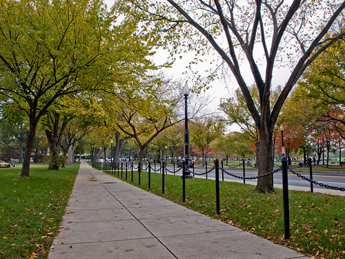
Shade is a moving network
Tree-canopy percentage is useful for describing a district, but it is a weak description of a journey. Shadows move with the sun. A leafy street at 10 a.m. may have an exposed pavement at 3 p.m. Buildings, awnings, arcades and trees all cast shade, but at different times and with different costs. The experience of a route is therefore determined not only by how much shade exists, but by when and where its gaps appear.
The physical mechanism is more surprising than “trees cool the air”. Direct solar radiation changes the radiant heat received by the body. In a recent field-validated study of hot, humid streets in Guangzhou, tree shade reduced mean radiant temperature by 14.2°C and the Universal Thermal Climate Index by 2.1°C on average under the studied conditions, while average air-temperature cooling was only about 0.1°C. That is one place and one set of conditions, not a universal conversion, but it shows why a person can feel meaningful relief even when the thermometer barely moves. The study’s geometry-resolved model also found that crown size, spacing and street orientation affected performance.
A route-level measure should therefore be temporal and continuous. Instead of asking only “What fraction of this neighbourhood is under canopy?”, ask: during the chosen heat window, what fraction of this essential route is shaded, and what is the longest continuous exposed segment? The second number matters because a route with 80 per cent shade can still contain one punishing gap outside a clinic, school or station.
Push the idea to city scale
Imagine a municipal shade standard with the logic of a transport service level. The city identifies essential pedestrian routes connecting homes and transit to clinics, schools, markets, libraries and public cooling spaces. For each route it specifies hours and seasons when shade continuity is expected, then publishes the maximum exposed gap and the places where the promise is not met.
This is technically possible. Massachusetts’ NO-HEAT project has combined one-metre heat-exposure mapping with sun angle, shadows, land cover, weather and walk-and-bike audits. It also installed shade structures at three high-risk locations and developed a prototype cooler-route tool. Phoenix’s Shade Phoenix plan, presented in November 2024, similarly prioritises places where vulnerable residents spend time outdoors and routes people use to reach work, buses and parks.
A guarantee would go further than either precedent. It would turn shade from an amenity delivered where convenient into a publicly inspectable obligation. That change is institutional as much as physical. Transport departments control pavements and sightlines; parks teams manage trees; building owners control façades and awnings; utilities occupy the soil; public-health teams know where heat risk is concentrated. A continuous route crosses all of their boundaries.
Where the guarantee breaks
The strongest objection is that a shade standard could become an attractive but shallow metric. A city might install photogenic canopies while neglecting hot homes, cooling centres, drinking water, worker protections or emergency warnings. The European Commission’s Joint Research Centre argues for combined heat strategies, including green and blue infrastructure, reflective materials, warning systems and shelters. A shaded route cannot substitute for that wider system.
Nor is every shadow equally durable. A young tree may take years to become useful and may fail without water and maintenance. A fabric canopy must withstand wind and avoid trapping heat. An awning can narrow a pavement or obstruct a mobility aid. Dense summer shade may be welcome while winter sun is valuable. Tree roots, underground utilities, delivery access and property boundaries constrain placement. Humidity and still air can remain dangerous even out of direct sun.
Distribution is another failure mode. If the first shaded routes follow retail investment rather than need, the guarantee will reinforce existing comfort gaps. Route selection should therefore begin with exposure and dependence: people who walk, roll or wait outdoors; places with little private cooling; essential destinations; and the resting points that determine whether a journey is possible. The public should be able to challenge both the map and the chosen service window.
Work back to one corridor
A city-wide promise should not begin with a city-wide construction programme. It should begin with a falsifiable corridor experiment.
Choose one essential route of roughly 500 to 1,000 metres—for example, a bus stop to a clinic, school or market. On two or three clear, warm days, walk or roll it at the hours the future guarantee would cover. At regular intervals, record whether the usable width of the pavement is shaded. Also note the start and end of every exposed stretch, seating, water, crossings, slope, obstructions and who is responsible for the adjoining land. Photographs should face the direction of travel so the audit records what a person encounters, not merely what exists overhead.
The first output is not a canopy map. It is a route profile with four measures: shaded fraction during the service window; the longest continuous exposed distance; accessible width; and the named maintenance owner for each intervention point. A simple solar-shadow model can then test whether the observed pattern persists across the relevant weeks, because a single walk captures only one sun angle.
Next, select the three worst gaps. Test reversible responses before committing to permanent construction: a permitted temporary canopy, a shade sail engineered for wind, movable planting where access permits, or an agreement with a building owner to trial an awning. Any structure needs professional checks for loading, fire access, sightlines and accessibility. Compare the route profile before and after, and ask users where heat still changes their decisions. Surface-temperature readings can be informative, but the primary question is whether the exposed journey became shorter and more usable.
No universal maximum gap should be invented in advance. A local threshold should be proposed, tested with people of different ages and mobility, and revised against observed heat conditions. The worthwhile result may be a number; it may instead be a rule that varies by gradient, destination or availability of rest.
The decision is concrete. Pick one journey that people cannot avoid, define the hours when shade is supposed to work, and find its longest exposed gap. If a small, reversible intervention measurably improves that route without creating new access or maintenance problems, a city has the beginning of a standard—not just another tree count.
Author
What concrete example would confirm or challenge this article?
Choose a reaction, write a comment, or ask your AI assistant to send a proposal for review. Comments are reviewed before publication.